Background
Most datasets in the County’s Open Data Portal leverage the GIS (Geographic Information System) functionality of the Open Data portal to visualize data on maps. Additionally, the County is making available to local municipalities detailed mapping and 3D imaging for use in public safety, public works, and other functions. The County recently upgraded the Property Information Portal, which now boasts a streamlined system for viewing property information, tax assessment data, and parcel documents maintained by Public Works and the Assessor’s office.
| Apps | Data |
|---|---|
| Property Records | Data Download |
| Beach Monitoring | County Open Data Portal |
| Apps Gallery | ESRI Open Data Portal |
Supervisor District Boundaries 2022
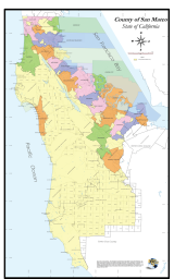
County Map
Includes city boundaries and unincorporated areas.

Questions? Contact the GIS Team at countygis@smcgov.org